

Main Territory Stakeholder Identification Interactive Map
To facilitate the identification of external stakeholders involved in a specific territory.
Designed for First Nations communities and organizations, this tool primarily serves to facilitate the identification of external stakeholders involved with the territory targeted by your protected area project.
It was developed to support the Practical Guide – How to Involve External Stakeholders in a Protected Area Project
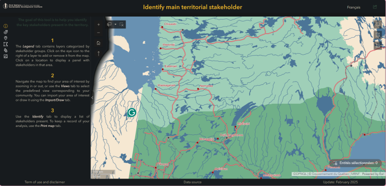
On a single map, you’ll find information on main territory stakeholders :
- First Nations in Quebec
- Administrations (Regional County Municipalities, municipalities)
- Natural resource exploitation companies (Non-indigenous forestry industries, mining industries, active mining titles, sugar bushes, blueberry fields, hydroelectric dams, power lines, pipelines, wind turbines)
- Protected areas register (Biological refuges, ecological reserves, national parks, proposed protected areas, biodiversity reserves, wildlife refuges, national wildlife areas, et Areas with other status)
- Environemental organizations
(Watershed organizations, Regional Environmental Councils, Priority Intervention Zone Committees) - Structured wildlife territories (Exclusive rights outfitters, Controlled harvesting zone, migratory bird sanctuaries, small managed lakes, wildlife reserves, regional parks, wildlife refuges, community wildlife areas, special agreements with indigenous peoples, educational and research forests)
- Tourism associations (Snowmobile trails)
- Government ministries (Forest Management Units, land Rights)
We recommend that you view this tool on your computer, as it is not optimized for use on small screens such as cell phones.
Our data sources for this tool
Hydro Québec, Ministère de l’Environnement, de la Lutte contre les changements climatiques, de la Faune et des Parcs (MELCCFP), Ministère des Ressources naturelles et des Forêts (MRNF), Natural resources Canada (NRCan), Stratégies Saint-Laurent
Disclaimer :
The information provided on this map/tool is redistributed from third-party sources and is not produced by the FNQLSDI. We do not guarantee the accuracy, completeness or up-to-date status of the data displayed. We may, in some cases, have purged, lightened or regrouped information in order to facilitate its application. Use of this map/tool is at your own risk. The FNQLSDI is not making any statements or recommending any action. Any attempt to use the information contained in this map to define, redraw or protest First Nations territories is strictly prohibited. We decline all responsibility for any loss or damage resulting from the use of the information contained on this map/tool.
Terms of use
-
-
- Acceptance of Terms : By accessing and using this map/tool, you agree to be bound by these terms of use. If you do not agree to these terms, please do not use this map/tool.
- Use of Data :The data displayed on this map/tool is redistributed from third-party sources. We do not produce any data and do not guarantee its accuracy. You agree to use this data at your own risk. The information provided is for general use only and should not be used to make important decisions without independent verification. Any use of the data for development, research or planning purposes should be made with caution and with due regard to the limitations of the data being redistributed.
- Confidentiality : This map/tool cannot be used to delimit First Nations territories. Any attempt to use the information contained on this map to define, redraw or protest First Nations territories is strictly prohibited. We respect the rights and self-determination of First Nations and will not contribute to actions that may prejudice these rights. Users of this map must also avoid any use that could violate the confidentiality or rights of First Nations communities.
- Limitation of Liability: : In no circumstances we shall be responsible for any direct, indirect or consequential damages arising out of the use or inability to use this map/tool or the information it contains.
- Intellectual Property : All intellectual property rights relating to this map/tool and its contents belong to their respective owners. You may not reproduce, distribute or use these contents without prior authorization, except in the case of open data. Please refer to the disclosed credits for details.
- Changes to Terms: We reserve the right to change these terms of use at any time. Les modifications seront effectives dès leur publication sur cette page. It is your responsibility to review these Terms regularly to ensure compliance..
-